New Study: Rethinking the Focus on Forest Fires in Federal Wildland Fire Management
Q&A with Michele Crist, Fuels Management and Fire Planning, Bureau of Land Management - National Interagency Fire Center, Boise, ID

A recently published paper in the Journal of Environmental Management looked at two decades of wildfire patterns and trends for areas that are forested and those that are not. This study showed that over half of the area burned across the western U.S. (not including Alaska and Hawaii) occurred in non-forest ecosystems. Results show that non-forest lands such as western shrublands and deserts had more area burned, larger fire sizes, and experienced an increase in frequent fire when compared to forested lands.
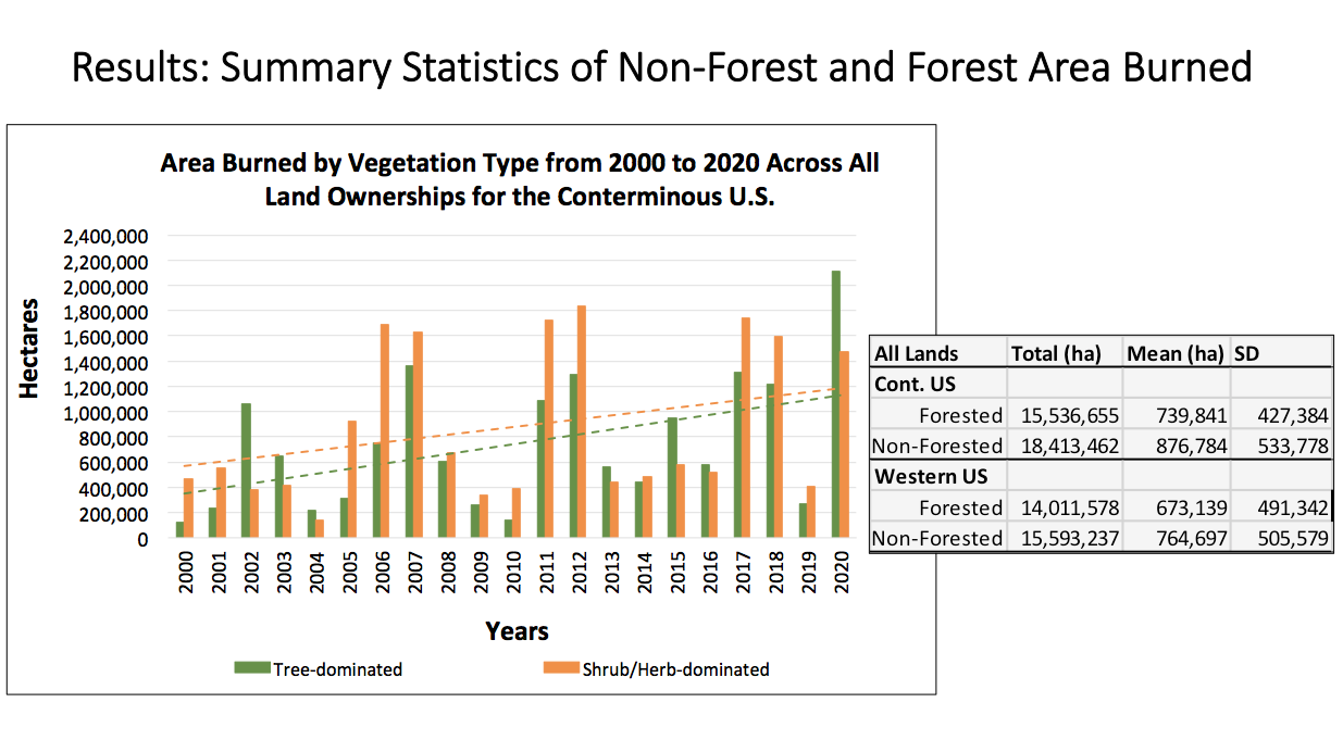
This is a graph showing that more acres burned on non-forested lands than on forested lands at two scales - the contiguous lower 48 states, and eleven western states.
This study of federal agencies showed increasing but opposite wildfire patterns and trends. For example, both the Department of Interior (DOI) and the U.S. Forest Service (USFS) experienced an increase in area burned over the past two decades, but 74% of the DOI burned area occurred on non-forest lands, and 78% of the USFS burned area occurred on forested lands. These results have implications for current wildland fire management programs because federal fire policy is more forest-centric and is likely missing the boat in reducing uncharacteristic fire across the western U.S. and protecting wildland urban interface communities, especially for DOI agencies such as the Bureau of Land Management.
The paper’s author, Michele Crist, answers a few questions about the analysis and what management implications this work revealed.
Q. What do the results of non-forested lands burning more frequently and in larger expanses mean?
Crist: The emerging non-forest fire patterns are primarily due to the rapid expansion of non-native invasive grasses (think cheatgrass) that increase fuel connectivity and fire spread. These invasions promote uncharacteristically frequent fire and loss of native ecosystems at large-scales, accelerating the need to place greater focus on managing invasive species in wildland fire management.
Q. Why was this analysis important to conduct at this time?
Crist: Certain regions of non-forest and forest lands are experiencing wildfire more often than they experienced historically. Given the ongoing and projected changes in climate and expansion of invasive non-native grasses in non-forested and forested ecosystems, some ecosystems will likely cross a threshold from their historical wildfire trends to novel fire trends of more frequent fire in the future. Large-scale fuels management strategies have not yet been developed to address areas that are burning too frequently or experiencing invasive grass induced wildfire regime changes. This study was conducted to gain a better understanding of large-scale wildfire patterns and trends for both non-forested and forested lands to help inform wildland fire policy and management strategies. Uncharacteristic fire due to the spread of fire-prone invasives is a large and pervasive threat to certain ecosystems’ persistence across the western U.S. and current federal management structures and budgets focused mainly on reducing forest and woodland fuels due to past fire suppression need to broaden to reflect that.
Q. How can the results included in this paper be used to impact on-the-ground land conservation?
Crist: These results can be used in three specific areas: The first is to inform wildfire management and policy aimed at reducing uncharacteristic wildfire processes and patterns for both non-forest and forest ecosystems. The second is to identify differing management strategies needed to address the unique wildfire issues each federal agency faces. The third is to provide information to help determine where non-forest and forest ecosystems are at risk of experiencing “too much fire”, especially where non-native invasive grasses are altering fire regimes, so that on-the-ground efforts can restore/protect these areas before they are lost.
Q. What are some other important takeaways from this study?
Crist: The use of landscape metrics in determining spatial wildfire trends can provide broad scale understanding of fire regime changes over time, important for informing wildland fire management decisions at national and regional scales. Landscape metrics can be used for agency prioritizations, performance measures, monitoring, evaluations, and adaptive management. Results of this study can be used to set baselines to evaluate where successes have been made and where shortfalls can be addressed in wildland fire management.

Graphs of two metrics results used to compare each agencies spatial and temporal trends of area burned (ha) for non-forest (orange) and forest (green). Trendlines were derived using linear regression and depict overall increase or decrease for the landscape metrics over time. Asterisks indicate a statistical significant difference in non-forest and forest area burned patterns.
For the BLM and DOI, percentage of area burned (PLAND) for non-forest was significantly higher than forest , and both agencies had an increase in non-forest area burned over time. For the USFS, a higher percentage of area burned occurred in forest, and temporal trends depicted a higher increase in forest burned area over time. The Large Patch Index indicated that large fires (large burned area patch sizes) were larger in non-forested areas and increased for non-forested area for BLM and the DOI over time. For the USFS, large fires (large burned area patch sizes) in forested areas decreased over time.

Spatial fire departure analyses can help identify causes for increased fire frequencies. These analyses combined with other information such as ignition patterns, changes in precipitation, temperature, weather patterns, and invasive grass spatial distributions, can help identify causes for increased fire frequencies and be used to determine needed fuels management strategies.
The fire regime departure map is shown here with the smaller map of invasive annual grasses across the Great Basin is from the Rangeland Analysis Platform. These graphics visually illustrate that the surplus of fire in the Great Basin correlates well with invasive grasses presence. Traditionally, wildland fire management has focused on areas with a lack of fire due to past fire suppression. Now, there a need to also address contemporary wildfire trends of “too much fire” in non-forested ecosystems.